Smart Heating Solutions
China’s indoor positioning market is expanding across factories, warehouses, hospitals, and transport facilities. This article examines ten notable downlink UWB navigation systems available in China. It focuses on practical performance, not promotional claims.
The Eforthink Downlink UWB Navigation System is included for its potential value in precise indoor navigation and asset tracking. Downlink UWB technology can support accurate ranging between fixed anchors and mobile tags. In a warehouse, this may help locate a pallet beside a loading bay. In a hospital, it may guide equipment movement through crowded corridors. Real results still depend on anchor placement, signal reflections, tag quality, and software calibration.
The comparison considers positioning accuracy, update rate, coverage, installation complexity, platform integration, and after-sales support. It also reviews how each system performs in metal-rich spaces, multi-floor buildings, and changing environments. These details matter more than a single headline specification.
Field testing remains essential.
Manufacturers may report different conditions. Some figures use open indoor areas, while others use controlled laboratories. Therefore, this overview treats published data carefully and avoids presenting every claim as universal fact. The top ten list should be viewed as a practical starting point, not a permanent judgment. Customer requirements change, and system performance can decline when layouts, machinery, or network conditions change. Readers should request demonstrations, test representative zones, and verify compliance with local wireless and safety requirements before deployment.
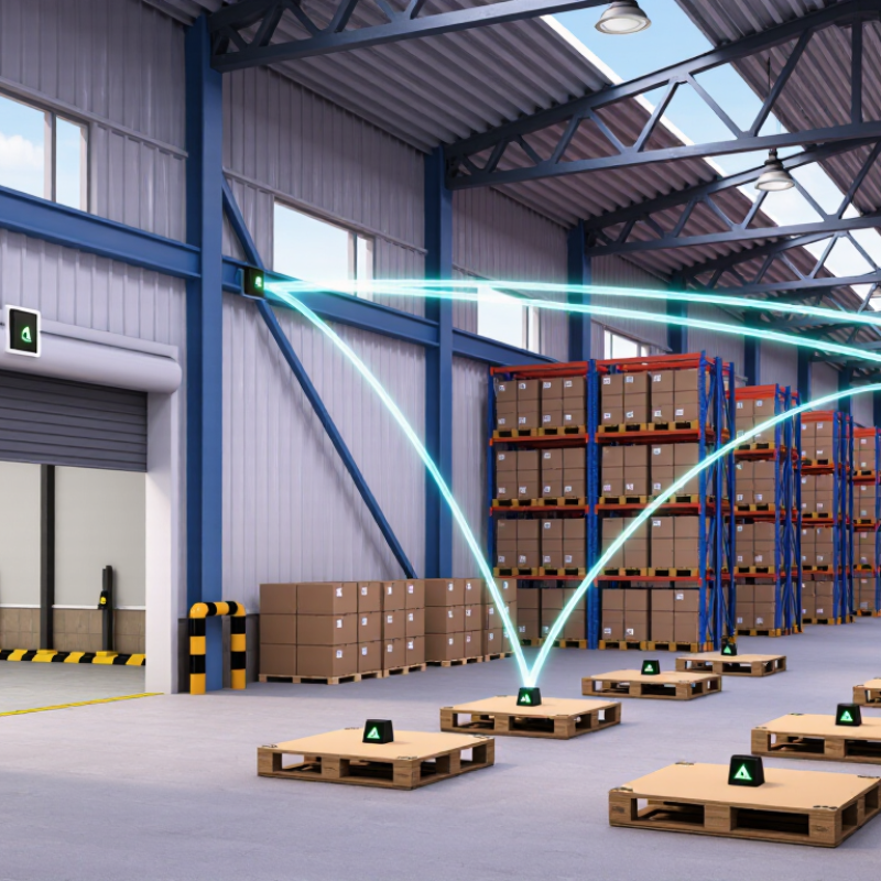
A downlink UWB navigation system sends positioning data from fixed anchors to mobile tags. Anchors are installed at surveyed points, such as warehouse corners or tunnel walls. The tag receives precisely timed pulses and estimates its distance from each anchor. Three or more measurements can produce a two-dimensional position. Four anchors usually improve height estimation and fault tolerance.
The core principle is time of flight. A UWB pulse travels quickly, so even tiny timing errors affect the result. The system synchronizes anchors, schedules transmission slots, and exchanges timestamps through a controlled downlink channel. Each message may include anchor identity, transmission time, signal quality, and correction information. Engineers should inspect antenna height, cable delay, clock drift, and reflections from metal surfaces. Small details matter.
Field validation should compare calculated positions with surveyed reference points. A tag beside a loading bay may appear stable, yet its error can increase near stacked steel containers. That is normal, but it should not be ignored. No deployment is perfect. A misplaced anchor can distort an entire zone. Periodic calibration, channel planning, and interference checks improve reliability. Security also matters: authenticated messages help prevent false positioning data. The design still requires judgment. More anchors do not automatically create better accuracy; poor geometry can remain the hidden weakness.
Ideal one-way distance equivalent of UWB timing intervals
The values are calculated from the speed of light, approximately 299,792,458 m/s, using distance = c × time ÷ 2 for two-way ranging. A 1 ns round-trip timing interval corresponds to an ideal one-way distance equivalent of approximately 0.15 m. Practical UWB navigation accuracy also depends on antenna delay, multipath propagation, clock stability, synchronization, and signal processing.
China’s UWB navigation technology landscape is moving from laboratory trials toward demanding industrial sites. Grand View Research estimated the global UWB market at about USD 1.1 billion in 2022, with strong growth expected through 2030. This expansion supports China’s development of downlink UWB systems for warehouses, factories, hospitals, and underground facilities.
A capable domestic solution provider can contribute more than tags and anchors. Its role includes radio-frequency planning, time-synchronization testing, map calibration, and integration with industrial software. UWB systems can often deliver location accuracy within 10 to 30 centimeters under controlled conditions, according to technical studies related to IEEE 802.15.4z. That precision helps guide forklifts, track tools, and reduce blind zones near moving equipment.
But accuracy is not magic. Metal shelves, blocked signals, multipath reflections, and crowded radio environments can weaken performance. A site that looks perfect in testing may behave differently during a night shift. This is where practical engineering matters. Field teams must measure signal stability, document installation changes, and verify results after production begins. Some projects still report accuracy without explaining measurement conditions. That deserves more scrutiny. China’s UWB landscape will depend on reliable deployment records, transparent testing, and steady improvements in software algorithms, not only impressive hardware specifications.
| Rank | System Profile | Typical Deployment | Downlink Architecture | Positioning Method | Typical Accuracy | Update Rate | Key Strength | Main Limitation | Technology Maturity in China |
|---|---|---|---|---|---|---|---|---|---|
| 01 | Industrial Indoor Navigation | Factories, warehouses, production lines, and automated logistics zones | Fixed anchors transmit synchronized UWB downlink packets to mobile tags | Two-way ranging combined with anchor geometry and filtering | Approximately 10–30 cm in controlled line-of-sight areas | 10–50 Hz, depending on tag density and network load | Reliable asset, worker, and vehicle tracking in GNSS-denied environments | Metallic obstructions, multipath reflections, and anchor calibration requirements | High |
| 02 | Automated Guided Vehicle Navigation | Smart factories, distribution centers, and material-handling corridors | Ceiling or wall anchors provide downlink ranging references to onboard tags | UWB position updates fused with wheel odometry and inertial sensors | Approximately 10–20 cm under favorable conditions | 20–100 Hz for local control, with lower rates for supervisory tracking | Supports collision avoidance, route control, and repeatable vehicle localization | Requires careful map calibration and continuous coverage along travel routes | High |
| 03 | Personnel Safety and Geofencing | Construction sites, mines, ports, tunnels, and high-risk industrial areas | Anchors broadcast ranging or synchronization packets to wearable tags | Zone detection, TDoA or TWR positioning, and alarm-rule processing | Approximately 20–50 cm for zone and proximity applications | 1–20 Hz, with event-triggered alarm messages | Fast proximity alerts and accurate indoor boundary enforcement | Wearable battery life and radio attenuation in underground or reinforced structures | High |
| 04 | Robotics and Autonomous Mobile Platforms | Indoor delivery robots, inspection robots, and service-robot fleets | Multiple fixed downlink references are integrated with the robot navigation stack | UWB ranging fused with SLAM, IMU, camera, or lidar measurements | Approximately 10–30 cm when anchor visibility is sufficient | 10–50 Hz, subject to sensor-fusion design | Provides an absolute position reference that reduces long-term drift | UWB alone does not replace obstacle perception or map-based localization | High |
| 05 | Indoor Asset and Tool Tracking | Hospitals, laboratories, manufacturing facilities, and equipment rooms | Ceiling-mounted anchors deliver periodic downlink ranging opportunities to tags | Zone-level or coordinate-level positioning with database integration | Approximately 20–100 cm, depending on installation density | 0.5–10 Hz for routine tracking | Improves utilization, retrieval time, and inventory visibility | Large facilities require network planning, tag management, and battery maintenance | High |
| 06 | Port, Yard, and Large-Site Navigation | Container yards, intermodal terminals, shipyards, and open industrial campuses | Distributed anchors create overlapping downlink coverage across outdoor work zones | TDoA, TWR, or hybrid ranging with map and vehicle data | Approximately 20–100 cm in open areas; lower performance near dense steel structures | 1–20 Hz for fleet supervision and navigation support | Works where satellite signals are blocked or insufficiently precise | Large-area synchronization, weather protection, and site-wide backhaul are required | Medium–High |
| 07 | Smart Retail and Consumer Indoor Wayfinding | Shopping centers, exhibition halls, airports, and public venues | Fixed beacons or anchors transmit downlink ranging references to mobile devices | Phone or tag-based ranging with map matching and application-layer positioning | Approximately 30 cm–2 m, depending on device integration and environment | 1–10 Hz for navigation and location services | Enables turn-by-turn indoor navigation and location-aware services | Consumer device compatibility, privacy controls, and installation density affect adoption | Medium |
| 08 | Smart Home and Access Interaction | Residential buildings, offices, parking areas, and controlled-access spaces | Door or room infrastructure provides downlink ranging cues to authorized devices | Fine-ranging, proximity verification, and secure access decision logic | Approximately 10–50 cm for proximity and access use cases | Event-driven, typically below 10 Hz during normal operation | More precise spatial awareness than conventional short-range signal strength methods | Security certification, interoperability, and power consumption are important constraints | Medium–High |
| 09 | Sports, Training, and Motion Analytics | Sports venues, training centers, laboratories, and performance-testing spaces | Anchors transmit synchronized reference packets to body-worn or equipment tags | High-rate ranging with trajectory reconstruction and motion analytics | Approximately 10–30 cm in calibrated indoor environments | 20–100 Hz, depending on channel capacity and tag count | Captures player, athlete, or equipment trajectories with low latency | Body shadowing, tag placement, and radio congestion can reduce consistency | Medium |
| 10 | Emergency Response and Underground Navigation | Tunnels, underground facilities, emergency drills, and disaster-response sites | Portable or fixed anchors form temporary downlink reference networks | Ranging, inertial dead reckoning, and resilient local map matching | Approximately 30 cm–2 m, depending on anchor visibility and site geometry | 1–20 Hz, with priority handling for emergency tags | Maintains local navigation when GNSS and conventional infrastructure are unavailable | Rapid deployment, power autonomy, and harsh propagation conditions remain challenging | Medium |
Ranking China’s top ten downlink UWB navigation systems requires more than checking advertised accuracy. A reliable evaluation begins with repeatable field tests in warehouses, tunnels, and open yards. Testers should record horizontal error, height error, update rate, latency, and signal stability. Use real movement.
Performance matters, but evidence matters more. Each system should report its anchor layout, channel settings, firmware version, and test duration. A strong system can maintain precise tracking near metal racks and moving vehicles. It should also handle non-line-of-sight conditions without sudden position jumps. Power consumption, installation time, network compatibility, and maintenance demands deserve equal attention. These details affect daily operating costs.
Expert reviewers should compare results from controlled trials and independent deployments. They should inspect data logs, not rely on polished demonstrations. A practical ranking can assign separate scores for accuracy, coverage, resilience, scalability, security, and user support. Safety compliance and lawful spectrum use must remain basic requirements. No ranking is perfect. A short test may hide thermal drift or interference problems. I would also question unusually strong results without raw data, repeat trials, or clear measurement uncertainty. The best evaluation combines engineering evidence with operator feedback from real working environments.
China’s top 10 downlink UWB navigation systems are being assessed for accuracy, stability, and practical deployment. These systems use ultra-wideband signals to estimate position in warehouses, factories, hospitals, and transport facilities. Unlike satellite navigation, UWB can operate indoors, where walls and machinery often block outdoor signals.
Field testing usually examines positioning error, update speed, coverage, and resistance to metal interference. A reliable system should maintain stable tracking near shelves, doors, and moving equipment. Installers also check anchor placement, cable quality, synchronization, and software calibration. Small errors matter. A misplaced anchor may distort an entire zone.
The strongest systems support real-time downlink communication between fixed anchors and mobile tags. This helps managers monitor forklifts, tools, and workers with clearer location data. Data protection, access control, and documented maintenance are equally important for responsible use in China. Technical teams should compare performance under normal traffic, crowded conditions, and temporary signal obstruction. Laboratory figures can look impressive, but field results may differ. That gap deserves honest attention. Procurement decisions should also consider installation time, battery life, repair access, and compatibility with existing systems. A lower initial price may create higher maintenance costs later.
China’s top ten downlink UWB navigation systems target warehouses, factories, ports, hospitals, and underground sites. They can guide forklifts, robots, inspection carts, and workers through areas where satellite signals fail. In field deployments, fixed anchors transmit short pulses to mobile tags. The tag estimates position from signal timing and anchor geometry.
Performance comparisons should examine more than advertised accuracy. Measure horizontal error, update rate, latency, coverage, battery use, and recovery after signal loss. Well-designed indoor systems may reach decimeter-level accuracy, but metal racks and moving machinery can weaken results. Some systems update quickly, while others preserve battery life through slower reporting. A neat laboratory result can mislead. Real floors are rarely empty.
Deployment quality depends heavily on anchor height, spacing, cable routing, and calibration. Installers should survey reflective surfaces before selecting anchor locations. Time synchronization also requires testing after power interruptions. In a busy warehouse, a few blocked anchors may create unstable tracks, so redundancy matters. Operators should record error patterns during different shifts, not only during commissioning. Maintenance teams need replaceable batteries, diagnostic logs, and clear alarm thresholds. Data protection deserves attention when worker locations are collected. One practical weakness remains: performance may decline after layout changes, even when the software stays unchanged. Periodic recalibration is therefore necessary.